

Standards Covered in this Section:
S6E3. Students will recognize the significant role of water in earth processes.
a. Explain that a large portion of the Earth’s surface is water, consisting of oceans, rivers, lakes, underground water, and ice.
b. Relate various atmospheric conditions to stages of the water cycle.
c. Describe the composition, location, and subsurface topography of the world’s oceans.
d. Explain the causes of waves, currents, and tides.
Essential Questions:
- What is the water cycle?
- How does fresh water flow your area?
- How does moving water change the surface of the Earth?
- How does erosion change the path of rivers and streams?
- What are three factors that influence stream erosion?
- What are the stages of a river?
- How does deposition change the flow of water?
- Why is understanding flood plains important?
- How does water flow underground?
- What is an aquifer?
- Where does ground water come out of the ground?
Section 1: The Flow of Water
Essential Question:
What is the water cycle?
What is the water cycle?

The water cycle is the continuous movement of Earth’s water from the ocean to the atmosphere to the land and back to the ocean.
The water cycle is driven by energy from the sun.
*This is review from elementary school.
The water cycle is driven by energy from the sun.
*This is review from elementary school.
Essential Question:
How does fresh water flow in our area?
How does fresh water flow in our area?
River Systems
River systems are divided into regions called watersheds.
Mississippi River Basin Northwest River Basin North Central River Basin
Columbia River Basin Missouri River Basin Ohio River Basin
Rio Grande Basin Arkansas Red-Basin River West Gulf River Basin
Colorado River Basin California Nevada River Basin Southeast River Basin
Northeast River Basin Mid-Atlantic River Basin
River systems are divided into regions called watersheds.
- Watersheds are also known as Drainage Basins.
- Drainage basins: the area of land that is drained by a water system
Mississippi River Basin Northwest River Basin North Central River Basin
Columbia River Basin Missouri River Basin Ohio River Basin
Rio Grande Basin Arkansas Red-Basin River West Gulf River Basin
Colorado River Basin California Nevada River Basin Southeast River Basin
Northeast River Basin Mid-Atlantic River Basin

Flow of Water through Georgia

Southeast River Basin
Georgia is located in the Southeast River Basin. The Southeast River Basin flows into the Gulf of Mexico and the Atlantic Ocean. All small streams, creeks, lakes, and rivers are tributaries to the flow of water in the watershed.
A tributary is a a river or stream flowing into a larger river or lake.

There are fourteen river basins, or watersheds, that lie within Georgia's borders. The Altamaha, Ocmulgee, Oconee, Ogeechee, Satilla, Savannah, and St. Mary's basins drain into the Atlantic Ocean.
The Chattahoochee, Coosa, Flint, Ochlocknee, Suwanee, Tallapoosa, and Tennessee basins drain into the Gulf of Mexico.
The Chattahoochee, Coosa, Flint, Ochlocknee, Suwanee, Tallapoosa, and Tennessee basins drain into the Gulf of Mexico.

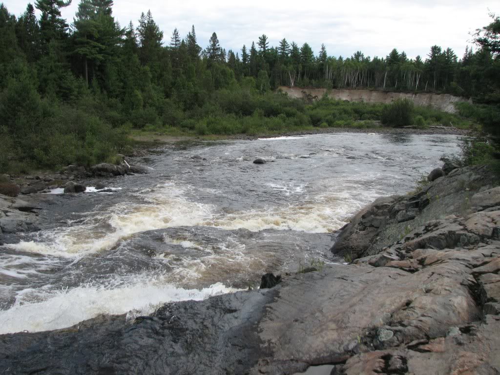
The Apalachicola-Chattahoochee-Flint River Basin is the main drainage basins for our area. In Douglas County, we are part of the Chattahoochee drainage basin. The Chattahoochee River flows through the southern border of our county. The Chattahoochee River has several dams built along its route to Lake Seminole, FL The Army Corp of Engineers build The Buford Dam, north of Atlanta, in 1956 for flood control and water use for the City of Atlanta. The West Point Dam was authorized by the Flood Control Act of 1962. Congress authorized the project for flood control, hydroelectric power, navigation, fish and wildlife development and general recreation. The Walter F. George Lock and Dam is located along the Alabama/Georgia south of Columbus, Ga. The Lock and Dam create Lake Eufaula for the purpose of recreation use. Finally, the Chattahoochee River flows into Lake Seminole at the Florida border and onto the Gulf of Mexico by way of the Apalachicola River at Apalachicola Bay.
Essential Question:
How does erosion change the path of rivers and streams?
How does erosion change the path of rivers and streams?

Erosion: the process by which soil and sediment are transported from one location to another
Types of Erosion:
Types of Erosion:
- Wind
- Rain
- Ice
- Snow
- Rivers as part of the water cycle
- As a stream forms, it erodes soil and rock to make a channel.
- Channel: the path that a stream follows
- When a stream forms, it channel is narrow and steep. Overtime, the stream transports rock and soil downstream and makes the channel wider and deeper.
- When a stream becomes longer and wider, it becomes a river.
- 3 Factors that influenced a stream’s ability to erode:
- Gradient (slope/steepness)
- Discharge (how much water flows down it)
- Load (the material carried downstream)
Essential Question:
What are three factors that influence stream erosion?
What are three factors that influence stream erosion?
3 Factors that influenced a stream’s ability to erode:
- Gradient (slope/steepness)
- Discharge (how much water flows down it)
- Load (the material carried downstream)
Three Types of Load
Bed load: a stream can bounce large materials, such as pebbles and boulders, along the stream bed.
Suspended load: a stream can carry small rocks and soil in suspension (makes a river look muddy)
Dissolved load: material carried in solution, which means that the material is dissolved in the water
Bed load: a stream can bounce large materials, such as pebbles and boulders, along the stream bed.
Suspended load: a stream can carry small rocks and soil in suspension (makes a river look muddy)
Dissolved load: material carried in solution, which means that the material is dissolved in the water
Essential Question:
What are the stages of a river?
What are the stages of a river?
Many factors in are included when describing the stages of a river.
- Climate
- Gradient
- Load

|
Youthful River:
|
Mature Rivers:
|

Old Rivers:
- Low gradient
- Little erosive energy
- Wide, flat flood plains, valley
- Many bends
- Few tributaries

Rejuvenated Rivers:
- Found where land is raised by tectonic activity
- Gradient becomes steeper, river flows more quickly
- Allows deep cuts into the valley floor
Essential Question:
How does deposition change the flow of water?
How does deposition change the flow of water?

Deposition: the process in which material is laid down
A river’s current slows when a river empties into a large body of water, such as a lake or an ocean. As its current slows, a river often deposits its load In a fan-shaped pattern.

Delta: a fan-shaped mass of material deposited at the mouth of a stream
These mud deposits form new land and cause the coastline to grow. The world’s deltas are home to a rich diversity of plant and animal life. |

Alluvial fans: fan-shaped deposits that, unlike deltas, form on dry land
Fast-moving mountain stream flows onto a flat plain, the stream slows down very quickly. As the stream flows down downward it deposits sediment. |
The okavango river, in Africa, flows approximately 1,600 km through Angola, Namibia, and Botswana before it empties into the middle of the Kalahari Desert, where the river evaporates! The rivers alluvial fan provides a haven for the desert’s plants and animals.
Essential Question:
Why is understanding flood plains important?
Why is understanding flood plains important?
Floodplain: an area along a river that forms from sediments deposited when the river overflows its banks
During periods of high rainfall or rapid snow melt, a sudden increase in the volume of water flowing into a stream can cause the stream to overflow its banks. Flood plains are rich farming areas because periodic flooding brings new soil to the land.
During periods of high rainfall or rapid snow melt, a sudden increase in the volume of water flowing into a stream can cause the stream to overflow its banks. Flood plains are rich farming areas because periodic flooding brings new soil to the land.
Essential Question:
How does water flow underground?
How does water flow underground?

Instead of turning on a faucet to get a glass of water, you pour water from a chunk of solid rock! This may sound crazy, but millions of people get their water from within rock that is deep underground.
This is called groundwater. Groundwater is located within the rocks below the surface. Groundwater is not only an important resource but it plays an important role in erosion and deposition.
This is called groundwater. Groundwater is located within the rocks below the surface. Groundwater is not only an important resource but it plays an important role in erosion and deposition.
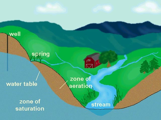
Surface water from rain seeps underground into the soil and rock. Underground water is divided into two zones:
Where the two zones meet is known as the water table.
- Zone of Aeration: zone where water passes through
- Zone of Saturation: where water fills the spaces between rock
Where the two zones meet is known as the water table.
Essential Question:
What is an aquifer?
What is an aquifer?
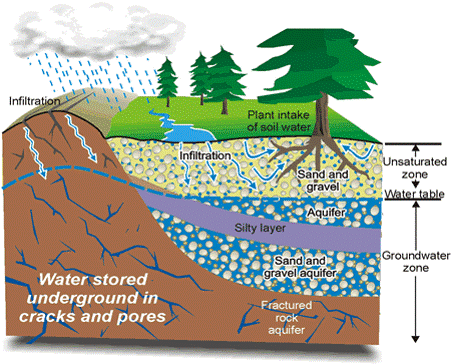
|
Aquifer: rock layer that stores groundwater and allows the flow of groundwater
Two Characteristics of Aquifers
|
|
United States Aquifers
|

|
Essential Question:
What is an aquifer?
What is an aquifer?
